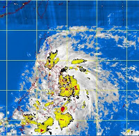
MANILA, Philippines–“Ofel” strengthened into a tropical storm on Wednesday and made landfall over Siargao, a teardrop-shaped island facing the Pacific, prompting weather officials to raise storm signals in over two dozen areas across the country.
 The storm hovered directly above Siargao island in Surigao del Norte at 10 a.m. and made its way toward the Visayas in a west northwest direction, the Philippine Atmospheric, Geophysical and Astronomical Services Administration said Wednesday.
Storm warning signals were hoisted over 26 provinces in Luzon, Visayas and Mindanao, Pagasa said in a bulletin.
Placed under Signal No. 2, with winds of 61-100 kilometers per hour, were Bohol, Cebu, including Camotes island, and the two Leyte provinces, in the Visayas; and Dinagat and Camiguin island provinces, and Surigao Del Norte, Surigao Del Sur, Agusan Del Norte, and the northern part of Agusan Del Sur, in Mindanao.
Under Signal No. 1, with winds of 30-60 kph, were Masbate and Romblon in Luzon; Northern Samar, Eastern Samar, Western Samar, Biliran, Capiz, Antique, Aklan including Boracay island, Iloilo, Guimaras, Negros Oriental, Negros Occidental and Siquijor island, in the Visayas; and Misamis Oriental, the rest of Agusan Del Sur and the northern part of Bukidnon in Mindanao.
Ofel was packing maximum sustained winds of 65 kph near the center and gustiness of up to 80 kph, Pagasa said. The bureau forecast that the storm would be moving in a west northwest direction at 19 kph.
“Storms that make landfall will usually weaken over a land mass and sometimes they dissipate, but because Visayas is a group of islands, we don’t expect that Ofel will decrease its strength by much,” Pagasa forecaster Jori Loiz said.
Ofel, he added, appeared to be interacting with a high pressure area in the West Philippine Sea. “We will have to observe if it will change directions,” he said.
Based on its current track, the storm is expected to be in the vicinity of Roxas City in Capiz by Thursday morning.
By Friday morning, it will likely be 180 km west of Nasugbu, Batangas and 640 km west of Manila by Saturday morning outside the Philippine area of responsibility.
Ofel has a diameter of 500 km. It will spawn moderate to intense rains, at 5 to 20 mm per hour within that range, Pagasa said.
The weather bureau issued its usual warning to residents living in low-lying and mountainous areas under Signals No. 1 and 2, to stay on guard for possible flash floods and landslides.
Likewise, those living in coastal areas under Signal No. 2 were alerted to possible storm surges.
Fishing boats and other small sea craft were also advised not to venture out into the eastern seaboard of Southern Luzon, the seaboards of Visayas and Mindanao due to the combined effect of Ofel and the northeast monsoon.
Source: http://newsinfo.inquirer.net/294936/ofel-intensifies-into-tropical-storm-pagasa


